File:1759 map Holy Land and 12 Tribes.jpg

Fayera repachivambo(2,000 × 1,676 pixels, file size: 1.74 MB, MIME type: image/jpeg)

Fayera rino rinobva kuWikimedia Commons uye rinogona kushandiswa nemimwe mwishumo. Mutsananguro uri pazanhi remutsananguro we fayera waro wakaratidzwa pazasi.

Muchipfupiso

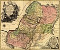
Tobias Conrad Lotter: Latina: Terra Sancta sive Palæstina exhibens no ſolum Regna vetera Iuda et Israel in ſuas XII Tribus diſtincta, ſed etiam eorundem diverſarum ætatum conditionem et facta in Sacris Paginis indicata.   (Wikidata search (Cirrus search) Wikidata query (SPARQL)  Create new Wikidata item based on this file)
Artist
Tobias Conrad Lotter  (1717–1777)  wikidata:Q106511
 
Alternative names
Lotter, Tobias Conrad / Lotter, Tobias Konrad
Description copper engraver, cartographer uye publisher
Date of birth/death 1717 Edit this at Wikidata 1777 Edit this at Wikidata
Location of birth/death Augsburg Augsburg
Work location
Authority file
artist QS:P170,Q106511
Title
Latina: Terra Sancta sive Palæstina exhibens no ſolum Regna vetera Iuda et Israel in ſuas XII Tribus diſtincta, ſed etiam eorundem diverſarum ætatum conditionem et facta in Sacris Paginis indicata.
Mutsananguro
English: English Translation: The Holy Land or Palestine showing not only the Old Kingdoms of Judea and Israel but also the 12 Tribes Distinctly, Confirming their Locations Diversely in their Ancient Condition and Doing So as the Holy Scriptures Indicate.
Musi 1759
date QS:P571,+1759-00-00T00:00:00Z/9
Medium hand-colored
Dimensions height: 47 cm; width: 57 cm
dimensions QS:P2048,47U174728
dimensions QS:P2049,57U174728
Library of Congress Geography and Map Division Washington, D.C. 20540-4650
Notes Scale [ca. 1:695,000]
Source/Photographer Geography and Map Division, Library of Congress
Other versions

Kurezinesa

This is a faithful photographic reproduction of a two-dimensional, public domain work of art. The work of art itself is in the public domain for the following reason:
Public domain

This work is in the public domain in its country of origin and other countries and areas where the copyright term is the author's life plus 100 years or fewer.


You must also include a United States public domain tag to indicate why this work is in the public domain in the United States.
The official position taken by the Wikimedia Foundation is that "faithful reproductions of two-dimensional public domain works of art are public domain".
This photographic reproduction is therefore also considered to be in the public domain in the United States. In other jurisdictions, re-use of this content may be restricted; see Reuse of PD-Art photographs for details.

Captions

Add a one-line explanation of what this file represents

Items portrayed in this file

depicts Chirungu

MIME type Chirungu

image/jpeg

checksum Chirungu

9aec441e2a748bb1f14eca6e42dd7d08ce2e766b

determination method Chirungu: SHA-1 Chirungu

data size Chirungu

1,827,878 byte

height Chirungu

1,676 pixel

width Chirungu

2,000 pixel

Nhoroondo ye fayera

Dzvanya pa musi/nguva kuti uringe fayera sekuoneka kwaraita panguva iyoyo.

Musi/NguvaMfananoudokoMitanduMushandisiKomenda
parizvino10:43, 12 Gunyana 2005Mfananoudoko weuhlovo sekubva 10:43, 12 Gunyana 20052,000 × 1,676 (1.74 MB)Humus sapiens~commonswiki1759 map: Terra Sancta sive Palæstina exhibens no folum Regna vetera Iuda et Israel in fuas XII Tribus diftincta... Source: Library of Congress historical maps Category:Historical maps of the Middle East Category:Israel

The following page uses this file:

Kushandiswa kwe fayera pasirose

Mawiki anotevera ayo anoshandisa fayera iri:

Ringa kushandiswa kumwe kwe vupasirose kwe fayera rino.