File:Oceans and seas boundaries map-en.svg

Size of this PNG preview of this SVG file: 800 × 406 pixels. Zvimwe misimbiro: 320 × 162 pixels | 640 × 325 pixels | 1,024 × 519 pixels | 1,280 × 649 pixels | 2,560 × 1,299 pixels | 4,000 × 2,029 pixels
Fayera repachivambo (SVG file, nominally 4,000 × 2,029 pixels, file size: 1.39 MB)
Muchipfupiso
| Mutsananguro |
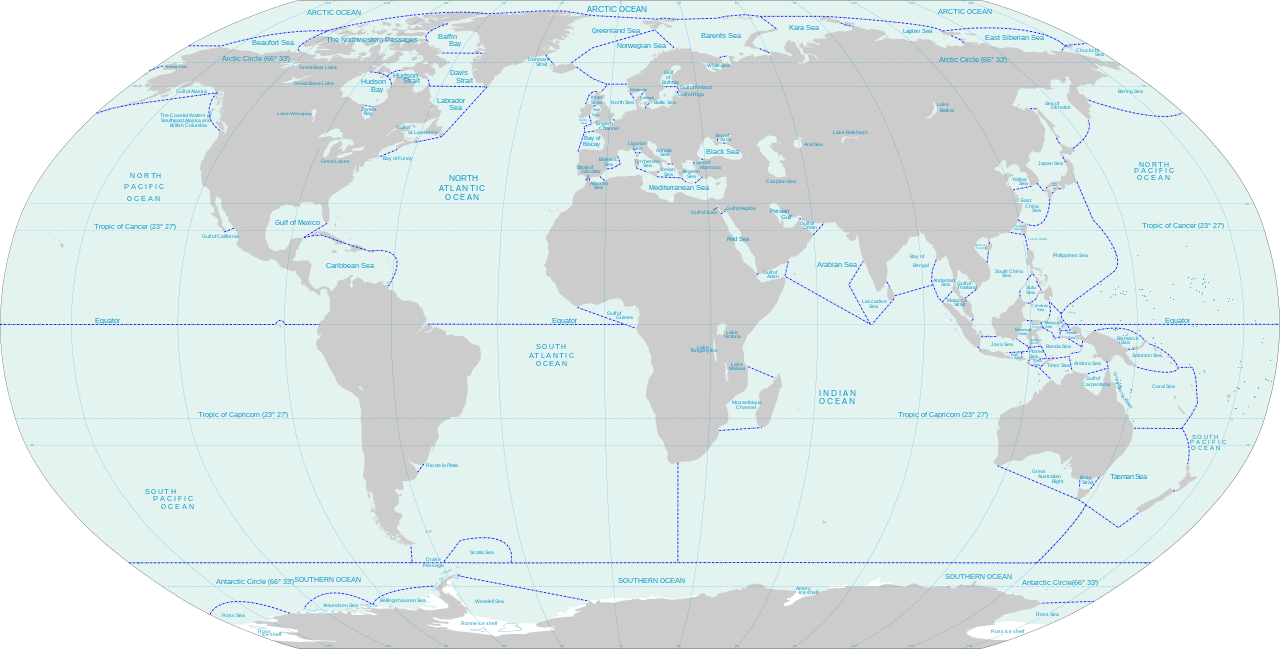
English: World map of oceans and seas : English version |
| Musi | (UTC) |
| Mabviro |
Own work using:
|
| Munyori | |
| Other versions | Turkish version, French version |
| This is a retouched picture, which means that it has been digitally altered from its original version. Modifications: Translated remaining French labels, fixed some English labels, added missing sea and lake names, added missing lake, refactored text styling of some labels to match the rest, fixed rainbow of colors assigned to random islands, added missing Malta and Bermuda islands. The original can be viewed here: Oceans and seas boundaries map-en.svg:
|
I, the copyright holder of this work, hereby publish it under the following licenses:
This file is licensed under the Creative Commons Attribution-Share Alike 3.0 Unported, 2.5 Generic, 2.0 Generic and 1.0 Generic license.
- Wakasungunuka:
- kugova – kucheza, kugovera ne kutumira basa
- kurhimikisa – kugadzirisa basa
- Pasi pemamiriro anotevera:
- Uzikano – Unofanhira kupa kiredhiti yakakodzeka, ipa kochekero yekune rezinesi, uye ratidza kana zvichinjirudzo zvaitwa. Ita sokudaro zviichienderana nenzira inonzwisisika, asi kwete nenzira ingaratidze zvekudii kuti murezinesi anokutsigira kana kushandiso kwako.
- gova saizvo – If you remix, transform, or build upon the material, you must distribute your contributions under the same or compatible license as the original.

|
Permission is granted to copy, distribute and/or modify this document under the terms of the GNU Free Documentation License, Version 1.2 or any later version published by the Free Software Foundation; with no Invariant Sections, no Front-Cover Texts, and no Back-Cover Texts. A copy of the license is included in the section entitled GNU Free Documentation License. |
Unokwanisa kusarura rezinesi inoenderana nezvaunoda.
Original upload log
This image is a derivative work of the following images:
- File:Oceans and seas boundaries map-fr.svg licensed with Cc-by-sa-3.0,2.5,2.0,1.0, GFDL
- 2021-04-05T01:32:50Z Dziban303 2753x1538 (1276318 Bytes) == {{int:filedesc}} == {{Information |Description={{en|World map of oceans and seas : English version}} |Source={{Derived from|Oceans and seas boundaries map-en.svg|display=50}} |Date=2021-04-05 01:09 (UTC) |Author=* [[:File:
- 2021-04-04T21:12:48Z Dziban303 2753x1538 (1268270 Bytes) == {{int:filedesc}} == {{Information |Description=English: World map of oceans and seas : English version|Source={{Derived from|Oceans and seas boundaries map-en.svg|display=50}} |Date=2021-04-04 21:10 (UTC) |Author=* [[:File:
- 2011-02-13T11:57:29Z Jugger90 2753x1538 (1263323 Bytes) {{Information |Description={{en|World map of oceans and seas : french version}} {{fr|Carte des océans et des mers du monde : version vide}} |Source=*[[:File:Oceans_and_seas_boundaries_map-fr.svg|]] |Date=2011-02-13 11:56 (UT
Uploaded with derivativeFX
Nhoroondo ye fayera
Dzvanya pa musi/nguva kuti uringe fayera sekuoneka kwaraita panguva iyoyo.
| Musi/Nguva | Mfananoudoko | Mitandu | Mushandisi | Komenda | |
|---|---|---|---|---|---|
| parizvino | 14:11, 11 Chikumi 2021 | | 4,000 × 2,029 (1.39 MB) | Ibrahim Muizzuddin | Edit toponymy, resize |
| 13:35, 11 Chikumi 2021 |  | 2,753 × 1,396 (1.22 MB) | Ibrahim Muizzuddin | Fit image | |
| 02:13, 5 Kubvumbi 2021 |  | 2,753 × 1,538 (1.22 MB) | Dziban303 | == {{int:filedesc}} == {{Information |Description={{en|World map of oceans and seas — English version}} |Source={{Derived from|Oceans and seas boundaries map-en.svg|display=50}} |Date=2021-04-05 02:11 (UTC) |Author=* File:Oceans and seas boundaries map-en.svg: *Oceans_and_seas_boundaries_map-fr.svg: Pinpin * derivative work: Jugger90 ([[User talk:Jugger90|<span cla... | |
| 01:32, 5 Kubvumbi 2021 |  | 2,753 × 1,538 (1.22 MB) | Dziban303 | == {{int:filedesc}} == {{Information |Description={{en|World map of oceans and seas : English version}} |Source={{Derived from|Oceans and seas boundaries map-en.svg|display=50}} |Date=2021-04-05 01:09 (UTC) |Author=* File:Oceans and seas boundaries map-en.svg: *Oceans_and_seas_boundaries_map-fr.svg: Pinpin *derivative work: Jugger90 ([[User talk:Jugger90|<span clas... | |
| 21:12, 4 Kubvumbi 2021 |  | 2,753 × 1,538 (1.21 MB) | Dziban303 | == {{int:filedesc}} == {{Information |Description={{en|World map of oceans and seas : English version}} |Source={{Derived from|Oceans and seas boundaries map-en.svg|display=50}} |Date=2021-04-04 21:10 (UTC) |Author=* File:Oceans and seas boundaries map-en.svg: *Oceans_and_seas_boundaries_map-fr.svg: Pinpin *derivative work: Jugger90 ([[User talk:Jugger90|<span clas... | |
| 11:57, 13 Kukadzi 2011 |  | 2,753 × 1,538 (1.2 MB) | Jugger90 | {{Information |Description={{en|World map of oceans and seas : french version}} {{fr|Carte des océans et des mers du monde : version vide}} |Source=*File:Oceans_and_seas_boundaries_map-fr.svg |Date=2011-02-13 11:56 (UTC) |Author=*[[:File:Oceans_and |
Kushandiswa kwe fayera
The following page uses this file:
Kushandiswa kwe fayera pasirose
Mawiki anotevera ayo anoshandisa fayera iri:
- Hushandiso pa ar.wikipedia.org
- Hushandiso pa ast.wikipedia.org
- Hushandiso pa bh.wikipedia.org
- Hushandiso pa blk.wikipedia.org
- Hushandiso pa bs.wikipedia.org
- Hushandiso pa ceb.wikipedia.org
- Hushandiso pa da.wikipedia.org
- Hushandiso pa de.wikipedia.org
- Hushandiso pa el.wikipedia.org
- Hushandiso pa en.wikipedia.org
- Hushandiso pa eo.wikipedia.org
- Hushandiso pa es.wikipedia.org
- Hushandiso pa eu.wikipedia.org
- Hushandiso pa fa.wikipedia.org
- Hushandiso pa fi.wikipedia.org
- Hushandiso pa id.wikipedia.org
- Hushandiso pa ilo.wikipedia.org
- Hushandiso pa it.wikipedia.org
- Hushandiso pa ka.wikipedia.org
- Hushandiso pa kn.wikipedia.org
- Hushandiso pa mk.wikipedia.org
- Hushandiso pa mn.wikipedia.org
- Hushandiso pa mr.wikipedia.org
- Hushandiso pa ms.wikipedia.org
- Hushandiso pa ru.wikipedia.org
- Hushandiso pa sh.wikipedia.org
- Hushandiso pa sl.wikipedia.org
- Hushandiso pa sv.wikipedia.org
- Hushandiso pa th.wikipedia.org
- Hushandiso pa ur.wikipedia.org
- Hushandiso pa vi.wikipedia.org
- Hushandiso pa zh.wikipedia.org