File:Red Sea topographic map-ar.png

Kukura kwe chipandwa ichi: 386 × 600 pixels Zvimwe misimbiro: 154 × 240 pixels | 309 × 480 pixels | 494 × 768 pixels | 659 × 1,024 pixels | 1,771 × 2,751 pixels
Fayera repachivambo (1,771 × 2,751 pixels, file size: 4.59 MB, MIME type: image/png)
Muchipfupiso
| Mutsananguro |
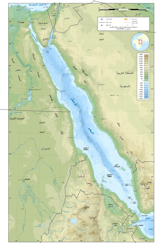
العربية: خريطة طوبوغرافية باللغة العربية للبحر الأحمر. |
| Musi | (UTC) |
| Mabviro |
This file was derived from: Red Sea topographic map-en.jpg:  |
| Munyori |
|
| This is a retouched picture, which means that it has been digitally altered from its original version. Modifications: translated to Arabic. The original can be viewed here: Red Sea topographic map-en.jpg:
|
Kurezinesa
I, the copyright holder of this work, hereby publish it under the following licenses:
This file is licensed under the Creative Commons Attribution-Share Alike 3.0 Unported, 2.5 Generic, 2.0 Generic and 1.0 Generic license.
- Wakasungunuka:
- kugova – kucheza, kugovera ne kutumira basa
- kurhimikisa – kugadzirisa basa
- Pasi pemamiriro anotevera:
- Uzikano – Unofanhira kupa kiredhiti yakakodzeka, ipa kochekero yekune rezinesi, uye ratidza kana zvichinjirudzo zvaitwa. Ita sokudaro zviichienderana nenzira inonzwisisika, asi kwete nenzira ingaratidze zvekudii kuti murezinesi anokutsigira kana kushandiso kwako.
- gova saizvo – If you remix, transform, or build upon the material, you must distribute your contributions under the same or compatible license as the original.

|
Permission is granted to copy, distribute and/or modify this document under the terms of the GNU Free Documentation License, Version 1.2 or any later version published by the Free Software Foundation; with no Invariant Sections, no Front-Cover Texts, and no Back-Cover Texts. A copy of the license is included in the section entitled GNU Free Documentation License. |
Unokwanisa kusarura rezinesi inoenderana nezvaunoda.
Original upload log
This image is a derivative work of the following images:
- File:Red_Sea_topographic_map-en.jpg licensed with Cc-by-sa-3.0,2.5,2.0,1.0, GFDL
- 2010-07-19T13:37:50Z Sting 1655x2705 (1756821 Bytes) Color profile
- 2008-09-02T04:47:27Z Sting 1655x2705 (1682874 Bytes) New standard colors ; bathymetry from ETOPO1 ; etc.
- 2008-04-03T19:35:00Z Sting 1655x2705 (1755258 Bytes) Additional corrections
- 2008-04-03T13:09:39Z Sting 1655x2705 (1788416 Bytes) Some names corrections ; some improvements
- 2008-04-03T11:26:39Z Sting 1655x2705 (1755771 Bytes) Little correction
- 2008-04-02T22:32:11Z Sting 1655x2705 (1786591 Bytes) {{Location|21|00|00|N|38|00|00|E|scale:10000000}} {{Information |Description={{en|Topographic map in English of the [[:en:Red Sea|red Sea]]''Note :'' for translation purpose, use the [[:Image:Red_Sea_topographic_map-en.svg|S
Uploaded with derivativeFX }}
Nhoroondo ye fayera
Dzvanya pa musi/nguva kuti uringe fayera sekuoneka kwaraita panguva iyoyo.
| Musi/Nguva | Mfananoudoko | Mitandu | Mushandisi | Komenda | |
|---|---|---|---|---|---|
| parizvino | 22:17, 10 Chikunguru 2012 | | 1,771 × 2,751 (4.59 MB) | باسم | == {{int:filedesc}} == {{Information |Description={{ar|خريطة طوبوغرافية باللغة العربية للبحر الأحمر. |Source={{Derived from|Red_Sea_topographic_map-en.jpg|display=50}} |Date=2012-07... |
Kushandiswa kwe fayera
The following page uses this file:
Kushandiswa kwe fayera pasirose
Mawiki anotevera ayo anoshandisa fayera iri: