File:Wales in the UK and Europe.svg

Size of this PNG preview of this SVG file: 713 × 600 pixels. Zvimwe misimbiro: 285 × 240 pixels | 571 × 480 pixels | 913 × 768 pixels | 1,218 × 1,024 pixels | 2,435 × 2,048 pixels | 2,045 × 1,720 pixels
Fayera repachivambo (SVG file, nominally 2,045 × 1,720 pixels, file size: 7.84 MB)
Muchipfupiso
| Mutsananguro |
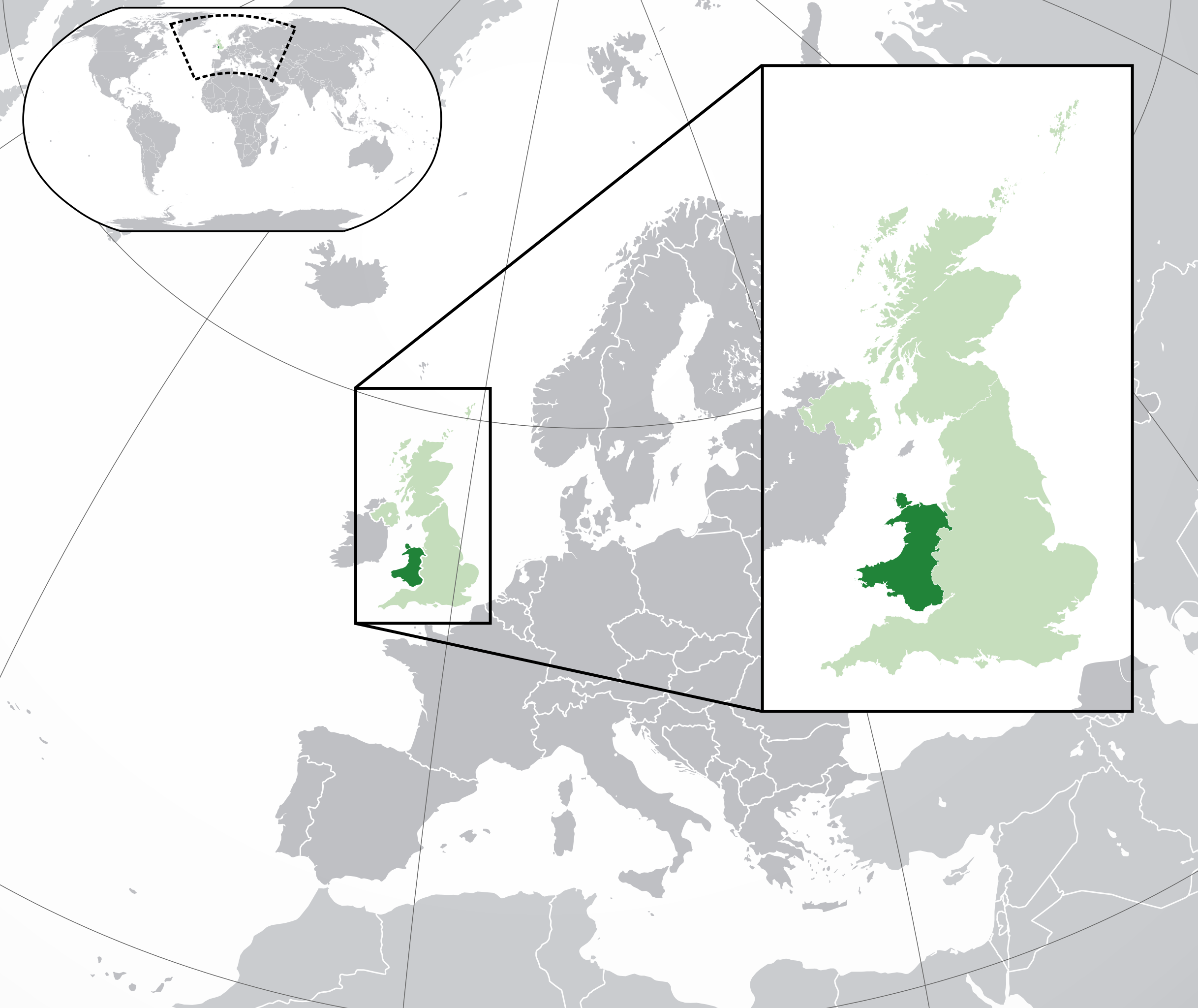
English: A map of Wales within the United Kingdom and Europe. The map is a polar orthographic projection.
Wales
United Kingdom (except Wales)
Europe (except UK) Français : Une carte du Pays de Galles au sein du Royaume-Uni et en Europe. La carte est un polair projection orthographique.
Pays de Galles
Royaume-Uni (sauf le Pays de Galles)
Europe (sauf le Royaume-Uni) Deutsch: Eine Karte der Wales drinnen das Vereinigtes Königreich und drinnen Europa. Die Karte ist ein polare orthografische Azimutalprojektion.
Wales
Vereinigtes Königreich (außer Wales)
Europa (außer das Vereinigtes Königreich) Cymraeg:
Cymru
Y Deyrnas Unedig
Ewrop Gàidhlig:
A' Chuimrigh
An Rìoghachd Aonaichte
An Roinn-Eòrpa Gaeilge:
An Bhreatain Bheag
An Ríocht Aontaithe
An Eoraip Kernowek: Kembra
Ruwvaneth Unys
Europa |
| Musi | (UTC) |
| Mabviro |
This file was derived from: Blank map of Europe (with disputed regions).svg: |
| Munyori |
|
| Other versions |
|
| SVG genesis |


.svg)
Kurezinesa
This file is licensed under the Creative Commons Attribution-Share Alike 3.0 Unported license.
- Wakasungunuka:
- kugova – kucheza, kugovera ne kutumira basa
- kurhimikisa – kugadzirisa basa
- Pasi pemamiriro anotevera:
- Uzikano – Unofanhira kupa kiredhiti yakakodzeka, ipa kochekero yekune rezinesi, uye ratidza kana zvichinjirudzo zvaitwa. Ita sokudaro zviichienderana nenzira inonzwisisika, asi kwete nenzira ingaratidze zvekudii kuti murezinesi anokutsigira kana kushandiso kwako.
- gova saizvo – If you remix, transform, or build upon the material, you must distribute your contributions under the same or compatible license as the original.
Original upload log
This image is a derivative work of the following images:
- File:Blank_map_of_Europe.svg licensed with Cc-by-sa-2.5
- 2012-02-21T16:27:27Z Alphathon 680x520 (614699 Bytes) Updated Metadata and the boarders/coastlines along the western coast of the Black Sea
- 2011-09-19T22:57:58Z Alphathon 680x520 (603759 Bytes) Added North/Northern Cyprus
- 2011-08-23T10:26:48Z Heb 680x520 (604212 Bytes) Added [[:en:Bornholm]] (taken from [[:File:Denmark blank map.svg]])
- 2011-04-12T00:40:40Z Alphathon 680x520 (602549 Bytes) Upgraded Sicily based on "File:Freeworldmaps-sicily.jpg". Upgraded Malta based on "File:Map of Malta 2.png". Simplified Croatian borders.
- 2011-04-10T21:43:04Z Alphathon 680x520 (607359 Bytes) Upgraded Croatia, Bosnia & Herzegovina, Slovenia and surrounding countries based on data from "File:Kroatien - Politische Gliederung (Karte).png"
- 2011-04-10T20:05:09Z Alphathon 680x520 (568373 Bytes) Improved Serbia, Montenegro and surrounding countries using data from "File:Serbia Map.png". Fixed Serbia-Montenegro border. Added Kosovo (using dashed border, since it is not a universally recognised nation, and left the lan
- 2011-04-10T15:55:02Z Alphathon 680x520 (524980 Bytes) Tweaked Ukraine and surrounding countries based on data from "File:Up-map.png"
- 2011-04-10T04:02:09Z Alphathon 680x520 (511168 Bytes) Improved Greece, Albania, F.Y.R. Macedonia and Bulgaria based on "File:Greece topo.jpg"
- 2011-04-10T02:48:52Z Alphathon 680x520 (505569 Bytes) Tweaked Germany and surrounding countries based on info from "File:Germany_general_map.png"
- 2011-04-10T01:54:05Z Alphathon 680x520 (493733 Bytes) Converted all lakes back to separate layer. Added Finish lakes and tweaked Finland shape based on "File:Finland 1996 CIA map.jpg". Added Swiss lakes based on "File:Suisse cantons.svg". Tweaked Scotland and added Lochs.
- 2011-04-10T00:07:54Z Alphathon 680x520 (450120 Bytes) Improved England outline and added Isle of Wight based on "File:England Regions - Blank.svg". Improved Denmark based on "File:2 digit postcode danmark.png". Improved Sweden based on "File:Map of Sweden, CIA, 1996.jpg"
- 2011-04-08T15:53:07Z Alphathon 680x520 (438878 Bytes) Upgraded/fixed various parts of the map. Details: *Some minor fixes to Ireland and added some of the larger lakes based on [[:File:Ireland_trad_counties_named.svg]] *Pretty major fixes to Scotland (mainly the west coast and i
- 2008-09-17T09:50:25Z F7 680x520 (531491 Bytes)
- 2008-09-17T09:42:57Z F7 680x520 (2353 Bytes)
- 2008-05-26T19:04:07Z Collard 680x520 (531491 Bytes) uploading on behalf of [[User:Checkit]], direct complaints to him plox: 'Moved countries out of the "outlines" group, removed "outlines" style class, remove separate style information for Russia'
- 2008-04-30T01:38:52Z TimothyBourke 680x520 (531767 Bytes) Changed the country code of Serbia to RS per [http://en.wikipedia.org/wiki/Serbian_country_codes] and the file [http://www.iso.org/iso/iso3166_en_code_lists.txt].
- 2008-02-08T22:44:37Z CarolSpears 680x520 (531767 Bytes) validated
- 2007-07-10T11:47:59Z MrWeeble 680x520 (533112 Bytes) Updated to include British Crown Dependencies as seperate entities and regroup them as "British Islands", with some simplifications to the XML and CSS
- 2007-05-14T17:17:34Z Zirland 680x520 (540659 Bytes) serbia and montenegro
- 2007-03-30T20:40:49Z W!B: 680x520 (538830 Bytes) minor corr: update nl:Ijsselmeer, del fi:lakes (all small), add ru:lake Oneka (all ref maps.google), glued northern irland back to ie ;)
- 2007-02-05T18:44:32Z Maix 680x520 (538295 Bytes) cropped
- 2007-02-04T15:07:29Z Maix 680x520 (538310 Bytes) {{Information |Description=A blank Map of Europe in SVG format. Every country has an id which is its ISO-3116-1-ALPHA2 code in lower case for easy coloring. |Source=Image based on [[Image:Europe_countries.svg|]] by [[User:Ti
Uploaded with derivativeFX
Nhoroondo ye fayera
Dzvanya pa musi/nguva kuti uringe fayera sekuoneka kwaraita panguva iyoyo.
| Musi/Nguva | Mfananoudoko | Mitandu | Mushandisi | Komenda | |
|---|---|---|---|---|---|
| parizvino | 20:00, 6 Nyamavhuvhu 2014 | | 2,045 × 1,720 (7.84 MB) | Rob984 | Improved version: More accurate coastline, borders, etc. Added Gradient and Longitude and latitude lines. Zoom insert centred on UK. |
| 14:58, 21 Kukadzi 2014 |  | 680 × 520 (2.48 MB) | Rob984 | White background so that the edge of the map is clear. Consistency with other European countries' maps also. | |
| 18:35, 19 Ndira 2013 |  | 680 × 520 (2.46 MB) | Alphathon | Added Robinson projection to the top left corner. | |
| 23:37, 26 Kukadzi 2012 |  | 680 × 520 (941 KB) | Alphathon | Fixed XML | |
| 23:35, 26 Kukadzi 2012 |  | 680 × 520 (941 KB) | Alphathon | More detailed British Isles | |
| 00:35, 26 Kukadzi 2012 |  | 680 × 520 (790 KB) | Alphathon | Added missing parts of Belgium and the Netherlands. | |
| 22:36, 25 Kukadzi 2012 |  | 680 × 520 (806 KB) | Alphathon | == {{int:filedesc}} == {{Information |Description={{en|A map of Wales (dark green) within the United Kingdom (dark and light green) and Europe (dark green, light green and darker grey).}} |Source={{Derived from|Blank_map_of_Europe.svg|display=50}} |Dat... |
Kushandiswa kwe fayera
The following page uses this file:
Kushandiswa kwe fayera pasirose
Mawiki anotevera ayo anoshandisa fayera iri:
- Hushandiso pa af.wikipedia.org
- Hushandiso pa af.wiktionary.org
- Hushandiso pa am.wikipedia.org
- Hushandiso pa ar.wikipedia.org
- Hushandiso pa arz.wikipedia.org
- Hushandiso pa be.wikipedia.org
- Hushandiso pa bg.wikipedia.org
- Hushandiso pa bh.wikipedia.org
- Hushandiso pa blk.wikipedia.org
- Hushandiso pa bs.wikipedia.org
- Hushandiso pa bxr.wikipedia.org
- Hushandiso pa cdo.wikipedia.org
- Hushandiso pa chy.wikipedia.org
- Hushandiso pa ckb.wikipedia.org
- Hushandiso pa csb.wikipedia.org
- Hushandiso pa el.wikipedia.org
- Hushandiso pa en.wikipedia.org
- Hushandiso pa en.wikinews.org
- Hushandiso pa en.wiktionary.org
- Hushandiso pa es.wikipedia.org
- Hushandiso pa et.wikipedia.org
- Hushandiso pa eu.wikipedia.org
- Hushandiso pa fa.wikipedia.org
- Hushandiso pa fiu-vro.wikipedia.org
- Hushandiso pa fi.wikipedia.org
- Hushandiso pa fi.wiktionary.org
- Hushandiso pa fr.wikipedia.org
- Hushandiso pa fy.wikipedia.org
- Hushandiso pa gd.wiktionary.org
- Hushandiso pa gn.wikipedia.org
- Hushandiso pa gu.wikipedia.org
- Hushandiso pa hak.wikipedia.org
- Hushandiso pa he.wikivoyage.org
- Hushandiso pa hi.wikipedia.org
- Hushandiso pa hr.wikipedia.org
- Hushandiso pa hr.wiktionary.org
- Hushandiso pa hu.wikipedia.org
- Hushandiso pa hy.wikipedia.org
- Hushandiso pa ia.wikipedia.org
Ringa kushandiswa kumwe kwe vupasirose kwe fayera rino.